
Environmental vulnerability varies across the Chesapeake Bay watershed
- by Marc Ribaudo
- 8/21/2014
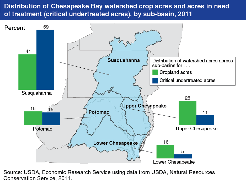
The Chesapeake Bay is North America’s largest and most biologically diverse estuary, and its watershed covers 64,000 square miles across 6 States (Delaware, Maryland, New York, Pennsylvania, Virginia, and West Virginia) and the District of Columbia. In 2010, the U.S. Environmental Protection Agency established limits for nutrient and sediment emissions from point (e.g., wastewater treatment plants) and nonpoint (e.g., agricultural runoff) sources to the Chesapeake Bay in the form of a total maximum daily load (TMDL). Agriculture is the largest single source of nutrient emissions in the watershed. About 19 percent of all cropped acres in the Chesapeake Bay watershed are critically undertreated, meaning that the management practices in place are inadequate for preventing significant losses of pollutants from these fields. Critically undertreated acres are not distributed among the four sub-basins in the same way as cropland. For example, the Susquehanna watershed contains 69 percent of critically undertreated acres but only 41 percent of cropland. Targeting conservation resources to highly vulnerable regions could improve the economic performance of environmental policies and programs. This chart displays data found in the ERS report, An Economic Assessment of Policy Options To Reduce Agricultural Pollutants in the Chesapeake Bay, ERR-166, June 2014.
We’d welcome your feedback!
Would you be willing to answer a few quick questions about your experience?