
Low incomes and no vehicle can limit food access
- by Economic Research Service
- 4/30/2013
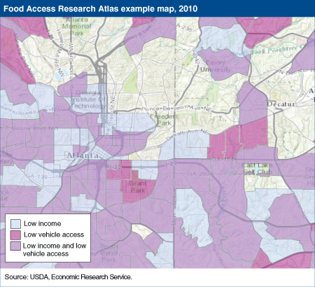
In addition to proximity of supermarkets, income and access to a vehicle both may be important indicators of whether individuals or families are able to attain a healthy and balanced diet. Shoppers who face the combined challenges of low incomes and no vehicle access may find traveling to a store that sells an affordable variety of nutritious foods to be more difficult for them than it is for shoppers who have higher incomes and access to a vehicle. In 2010, about 40 percent of U.S. census tracts were low income tracts, defined as having a poverty rate greater than 20 percent or a median family income less than 80 percent of the surrounding region’s median family income. Twenty-two percent had low vehicle access in which at least 100 households have no access to a vehicle. About 14 percent of all tracts faced the dual problems of low incomes and low vehicle access. In this example map of Atlanta, GA, and the surrounding region from ERS’s Food Access Research Atlas, the light blue areas indicate low income neighborhoods, and areas shaded in dark pink are those with low vehicle access. Some residents of the purple areas face a combination of low incomes and low vehicle access. This map and others showing different indicators of food access can be found on ERS’s Food Access Research Atlas.