
Visualizing Farm Program Participation and Benefits Across the U.S.
- by Anne Effland, Erik O'Donoghue, Vince Breneman and David Nulph
- 3/1/2012
U.S. farm programs assist farmers in sustaining their farm businesses or in protecting and enhancing the environment. Because program designs and purposes vary, agricultural producers may participate in multiple programs on the same farm. For example, programs may be tied to specific commodities or to whole farm revenues, they may provide support for current losses or be based on historical production, or they may be in the form of multiyear contracts for conservation practices. As a result, program expenditures can vary depending on factors such as individual producers' commodity choices, market conditions, weather patterns, pest infestations, and environmental conditions.
ERS's Farm Program Atlas provides access to an array of public data that enable users to visually explore the geographic distribution of participation and benefits from seven key Federal farm programs at national, State, and county levels. The Atlas currently includes data for program year 2009 (the most recent year for which data on all included USDA programs were available) for the Direct and Countercyclical Program (DCP), the Average Crop Revenue Election (ACRE) Program, the Marketing Assistance Loan Program, the Supplemental Revenue Assistance (SURE) Program, the Milk Income Loss Contract (MILC) Program, the Conservation Reserve Program (CRP), and the Crop Insurance Program. The Atlas includes data by county for total expenditures and participation for each program and, in some cases, for selected commodities. The share of each program in the totals of included programs is also available. Users can easily download maps from the Atlas in jpeg format and access the data behind the maps through a downloadable Excel spreadsheet.
The maps in the Atlas can be explored at various geographic levels using a zoom tool, and details on individual counties for a selected program can be obtained through popup tables generated by clicking on the counties. For example, users can examine crop insurance adoption in different areas and compare farmers' selections of the type of policies that protect a farm's revenue. Zooming in on Iowa and clicking on Hamilton County, in the heart of the Corn Belt, reveals that 93 percent of all the cropland in that county is covered by crop insurance and that 85 percent of covered acres are insured by revenue protection policies, which protect against both price and yield shortfalls. In cotton-dominated Lynn County, TX, almost all cropland in the county was covered by crop insurance policies, but only a small share of covered acres were insured with revenue-based policies. Users can then zoom out to visually compare levels of adoption and policy selection in surrounding counties, States, or at the national level (the following maps illustrate how the Atlas can be used).
Image
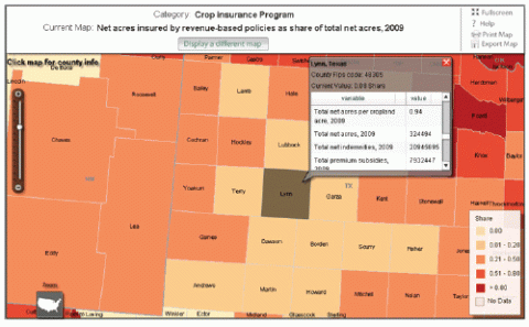
This map shows Lynn County, TX, and surrounding counties. Data in the popup table show that crop insurance policies covered 94 percent of all cropland acres (almost 325,000 acres) within Lynn County in 2009. Producers chose to cover only 8 percent of these acres with revenue-based insurance policies. Additionally, farmers received close to $8 million in subsidies on the premiums for these policies and roughly $21 million in net indemnities. Farmers in most surrounding counties also covered relatively few of their acres with revenue-based insurance policies.
Image
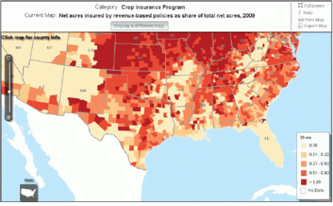
Users zooming out to gain a more regional view of the same map can see that in program year 2009, farms in Texas counties displayed a similar pattern of wide variation in use of revenue-based insurance policies to that of other States across the southern tier of the U.S.
Image
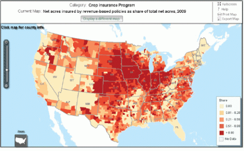
At the national level, users can see that the varying pattern of revenue-based insurance use in the southern tier of States differs significantly from the dominance of revenue-based insurance in most counties of the Plains and Heartland.
This article is drawn from:
- Farm Program Atlas. (2015). by Anne Effland, Vince Breneman, David Nulph, and Erik O'Donoghue, USDA, Economic Research Service.