Behind the Data
- by John Cromartie
- 11/1/2005
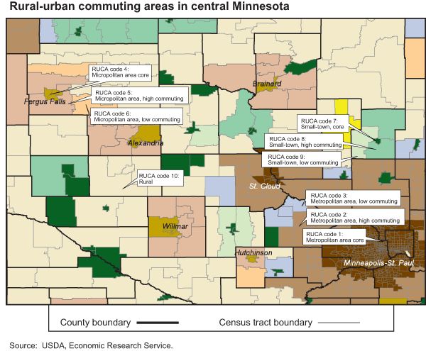
Rural-Urban Commuting Areas
ERS researchers and others who study conditions in rural America most often refer to conditions in nonmetropolitan (nonmetro) counties. Rural research and policymaking rely heavily on county-based approaches, but demand is increasing for greater geographic detail. The ERS rural-urban commuting area (RUCA) codes provide a flexible scheme for such a delineation because they employ a smaller unit of analysis—the census tract. The most recent version classifies census tracts using data from the 2000 decennial census, and is patterned after the metropolitan (metro) county classification system defined by the Office of Management and Budget (OMB).
As defined by OMB, metropolitan (metro) areas include central counties with one or more urbanized areas of 50,000 or more people and outlying counties that are economically tied to the central counties as indicated by high work commuting. The remaining nonmetro counties are subdivided into two types: micropolitan (micro) areas and all remaining noncore counties.
RUCA codes classify census tracts using the same concepts of population density, urbanization, and daily commuting as OMB. The RUCA codes adopted terminology to highlight this underlying connectedness. Metro core areas identify continuously built-up areas of 50,000 or more people and micro cores contain populations of 10,000-49,999. By using census tracts instead of counties as building blocks for RUCA codes, small town core areas with populations between 2,500 and 10,000 could be added.
The classification contains two levels. At the first level, census tracts are classified based on the size and direction of their primary (largest) commuting flows (codes 1-10). Metro, micro, and small town cores (codes 1, 4, and 7) are defined as census tract equivalents of central counties. High commuting (codes 2, 5, and 8) means that the largest commuting share is at least 30 percent to a nearby metro, micro, or small town core. Low commuting (codes 3, 6, and 9) refers to cases where the single largest commuting flow is to a core but is less than 30 percent. The last of the general classification codes (10) identifies rural tracts where the primary flow is local or to another rural tract.
At the second level, the primary RUCA codes are subdivided to identify areas where classifications overlap, based on the size and direction of the secondary, or second largest, commuting flow. For example, rural tracts for which the primary commuting share is local but more than 30 percent also commute to a nearby core are coded 10.1 for metro, 10.2 for micro, and 10.3 for small town cores. Few, if any, research or policy applications would likely need the full set of 30 codes. Rather, the system allows for the selective combination of codes to meet varying needs.
You may also like:
- Rural-Urban Commuting Area Codes. (n.d.). U.S. Department of Agriculture, Economic Research Service.


