
Profiles
- Contact: Website Administrator
- 6/1/2003
Farm Bill Analysis Team
The new Farm Bill was just 9 days old when the Economic Research Service posted a unique resource on the web, comparing key provisions of old and new legislation in a side-by-side format, for each of the bill’s 11 titles. In addition, this new web subsite provided preliminary economic analysis of selected provisions of the new law—the Farm Security and Rural Investment Act of 2002. Response was instantaneous, with over 52,000 hits on May 22, the day of the launch, climbing to 61,000 daily in the following week.
The relatively swift and seemingly effortless appearance of this time-saving reference on the ERS website was the work of a team of 29 analysts, writers, and editors, including a web designer, that was supported by dozens of other ERS analysts. The team’s expertise spanned program areas covering commodities, trade, conservation, nutrition, rural development, and research. “Timing was everything,” commented senior economist Ed Young, who directed the endeavor and wrote a large share of the content. “We wanted to make this resource available to the public as quickly as possible after the bill passed.” In the months before passage of the bill, team members closely monitored its progress and drafted early summaries and analyses. The anticipatory work, along with policy analysis ERS had developed over several years, laid the groundwork for relatively rapid completion of the Farm Bill site once the new legislation was signed into law.
The ERS Farm Bill summary and overview included a glossary, plus links to ERS and USDA material to help put the legislation in perspective. The ERS product was a linchpin in USDA’s suite of Farm Bill resources—all available on the web shortly after passage ofthe bill.
The ERS web pages continue to attract users searching for concise information on the Farm Bill. The Farm Bill site tallied more than 170,000 visits by the end of 2002, and over 30,000 this year. Says Ralph Heimlich, who directs policy analysis in the agency’s Resource Economics Division: “This group effort is a prime example of how government agencies are harnessing web technology to improve service to large and diverse audiences.”
Image
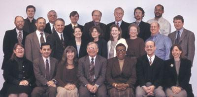
Back row (L to R): Stephen Peterson, Paul Westcott, Richard Reeder, Jan Lewandrowski, Marvin Duncan, Andrea Cattaneo, Kevin Ingram. Middle row (L to R): Ralph Heimlich, Paul Heisey, Roger Claassen, Joy Harwood, Mary Reardon, Kelly Day-Rubenstein, Lewrene Glaser, David Hopkins, Michael Price. Front row (L to R): Anne Effland, Ronald Trostle, Adrie Custer, Ed Young, Letricia Womack, Steven Koenig, Marca Weinberg. Not pictured: Margaret Andrews, Dwight Gadsby, Daniel Hellerstein, David Johnson, Kathleen Kassel, Cassandra Klotz-Ingram
Calvin Beale
This year, the Office of Management and Budget announces a revised definition of U.S. metropolitan areas—a key concept that shapes the reporting of Federal statistical data (notably the Census) and the funding of government programs. ERS Senior Demographer Calvin Beale served on the select interagency committee that developed the standards for defining metro areas, lending his prodigious expertise on rural-urban population patterns.
This contribution is just one among Calvin's many influential accomplishments over a 56-year career. He is recognized this year for consistently outstanding achievements during those five decades. (See Amber Waves, February 2003)
Image
Global Food Security Team
At the World Food Summit in 1996, leaders from across the globe set a goal of halving world hunger by 2015. The innovative contributions and insights of the ERS Global Food Security Team have been instrumental in helping shape the U.S. response to the challenge.
The seven-member team was formed in 1995 in response to an interagency request to publish a background paper assessing food security in low-income countries for the 1996 World Food Summit. It later drafted the U.S. position paper for the follow-up summit in 2002. “The original request catalyzed new forces on food security,” says team leader Shahla Shapouri, “which have been carried through in our work ever since.” Those ensuing efforts have been wide ranging, as the research focus has been extended to agricultural productivity and growth, trade, and other factors that can affect food security, which is generally defined as access at all times to enough food for active, healthy living. The team’s analysis also covers U.S. household food security.
The team has been an invaluable resource in the fight to reduce hunger. As part of a United Nations (UN) working group, team members influenced the development of an approach to measure the number of people at risk of hunger and malnutrition, which is now a critical operational element in the UN World Food Program. They provided input in a program to expand U.S. market access for African exports. Improved market access is vital to food-deficit countries, which use export earnings to finance food imports. The team’s body of work has also served to bolster congressional testimony and U.S. participation at several international forums, including the December 2002 G-8 meeting.
Progress in meeting the World Food Summit’s overall goal has been slow to date, and significant challenges remain. ERS’s Global Food Security Team will continue to serve as a complement to the U.S. foreign food assistance mission, providing policymakers and others with analysis on the nature, scope, and root causes of hunger and food insecurity. Adds Shahla, “We see the fruits of our efforts when other agencies and organizations use our work and decisions are made based on our research results.”
For more information, see International Food Security and Food Security in the U.S.
Image

Back row (L to R): Michael Trueblood, Stacey Rosen, Keith Wiebe; Front row (L to R): Mark Nord, Shahla Shapouri, Birgit Meade Not pictured: Margaret Andrews
A Window into the past. . .Francis Joseph Marschner
These days we are used to seeing land use imagery from space, with computers receiving and collating billions of bits of data from satellites in a single pass over the continent. Francis Marschner, a USDA geographer in both the Bureau of Agricultural Economics (BAE) and Economic Research Service, went about it the hard way in the 1920s and 1930s. By painstakingly consulting survey field notes, aerial photographs, and statistical compilations, he fashioned continental scale maps of land use. This pioneering work established the interdisciplinary approach to land use research in BAE and ERS that informed conservation and land development programs at the Federal and State level, and expanded cartographic methods for depicting economic and physical data.
Born in Austria in 1882, Marschner studied at the Cartographic Institute in Berlin, before immigrating to the United States in 1915. His work at USDA began with the Atlas of American Agriculture, published between 1922 and 1936. In 1945, he began work on Major Land Uses in the United States, published in 1950, which contained the first authoritative medium-scale U.S. land use map, printed in the National Atlas of the United States. The Major Land Uses series has been published every 5 years ever since, and is still the only comprehensive picture of all land uses for the U.S. prepared by the Federal government. The Association of American Geographers awarded this work its citation for meritorious work, the hallmark of Marschner’s career.
Another major work was Land Use Patterns in the United States, a collection of 168 aerial photographs depicting the variety of landforms across America. Marschner received USDA’s Superior Accomplishment Award in 1947, and in 1963 was elected a fellow of the American Association for the Advancement of Science.
Marschner retired from USDA’s BAE in 1952, but continued to work under a special unpaid joint appointment in ERS and USDA’s Agricultural Research Service, walking nearly 7 miles to work each day. Marschner never married and had no relatives in the country, but, according to the Annals of the Association of American Geographers, he had “the devotion of his ‘family’ of friends in the Department of Agriculture.” He died on January 31, 1966, walking to work at age 83.
Image
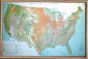
Using survey field notes, aerial photographs, and statistical compilations, Francis Marschner created the first authoritative medium-scale U.S. land use map in 1950. This version of the map, published in 1958, depicts twelve categories of land use, ranging from cropland and pastureland to desert and marshland. The heir to Marschner’s work at ERS is the Major Uses of Land in the United States, 1997.