

Cost Savings From Precision Agriculture Technologies on U.S. Corn Farms
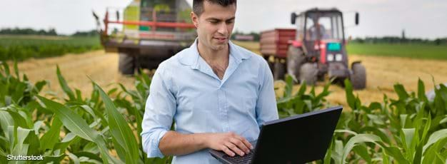
Information-based production (precision agriculture) technologies are growing in popularity with farmers because their use can lead to closer monitoring of farm-production management decisions and possible cost savings. According to USDA’s Agricultural Resource Management Survey, four technologies are the most commonly used: yield mapping, soil mapping, auto-guidance machinery steering, and variable rate technologies (VRT).
The first three of these technologies can be used independently of each other. Yield-monitoring harvesters produce location-specific crop yield data that report growing conditions during the previous growing period. These data can be used to create a yield map. Soil maps created using global positioning system (GPS) technology provide information on soil-related growing conditions on corn farms. Nitrogen, potassium, and phosphorous levels are commonly mapped, but soil type and micro-nutrients can be included. Both of these soil and yield types of GPS maps are being used by farmers, suppliers of agricultural inputs (e.g., seeds and fertilizer), and custom service providers for farm-production management recommendations and decisions.
Combine and tractor auto-guidance systems that self-steer farm equipment also require the use of GPS technology to determine field boundaries. Auto-guidance provides the benefit of more accurate field operations than can usually be done using visual cues, like manually steering along a row of crops.
VRT is the only one of the four technologies that is generally adopted in conjunction with other precision technologies. VRT is considered to be complementary to mapping and may lead to different cost savings when used with different types of mapping. For example, VRT-capable equipment used for applying agricultural inputs can be programmed by farmers using either yield maps or soil maps to apply different levels of inputs, even seeds, at different rates within a field.
To estimate the cost savings from use of precision agriculture technologies in corn production, ERS researchers analyzed factors related to technology adoption and corn production practices. Researchers accounted for the effects of acres farmed, level of higher education of the operator, and age of the operator. Per acre production cost was measured as operating costs for seed, fertilizer, pesticides, paid and unpaid labor, machinery expenses (not capital investments), fuel and repairs, and custom service expenses.
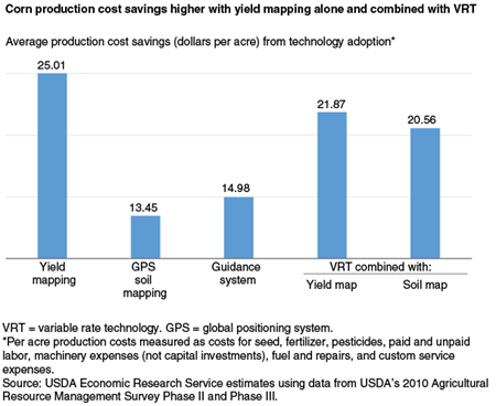
Among corn farmers using these four precision agriculture technologies, those using yield mapping independently or with VRT reported the largest cost savings (about $25 per acre). Yield monitors collect information on growing conditions throughout the year that are reflected in yields, and yield variability across a farmer’s fields gives a rich source of information on the effectiveness of recent practices. Farmers using soil mapping with GPS had cost savings of over $13 per acre, less than half that of farmers using yield mapping, as each data point on a soil map requires an individual geo-located soil test.
When comparing cost savings from VRT with yield mapping to cost savings from VRT with soil mapping, it might be expected that the additional density of information on a yield map would pay off when combined with VRT, and model results confirm this effect—VRT with yield mapping is associated with slightly higher per acre savings ($22 versus $21). Guidance systems require tractor and combine steering hardware, in addition to a GPS receiver, but their use still leads to higher cost savings ($15 per acre) than soil mapping. Guidance systems save fuel and wear on machines through easier management of field activities. Reduced operator fatigue and other stress-related factors are hard to measure and their effects are not accounted for in the cost savings from guidance systems. Relative to total per acre production costs, the estimated savings are 4.5 percent with yield mapping, 2.4 percent with GPS soil mapping, 2.7 percent with guidance systems, and between 3.7 and 3.9 percent with VRT.
“Sequential Adoption and Cost Savings from Precision Agriculture,” by David Schimmelpfennig and Robert Ebel, Journal of Agricultural and Resource Economics