ERS Charts of Note
Subscribe to get highlights from our current and past research, Monday through Friday, or see our privacy policy.
Get the latest charts via email, or on our mobile app for  and
and 

Wednesday, July 11, 2012
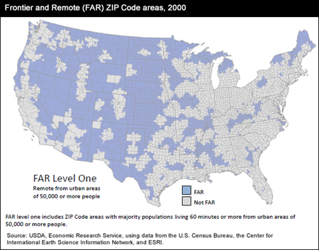
Population retention, job creation, and acquisition of goods and services often require increased effort in very rural, remote U.S. communities. ERS has developed a set of frontier and remote (FAR) area codes to aid research and policymaking on such communities. The initial version classifies ZIP code areas and includes four FAR level codes, based on different population and travel-time thresholds. The levels are meant to reflect likely access to various levels of public and private services. Level one-shown on the map-identifies areas lacking easy access to services commonly provided in large urban centers, such as advanced medical procedures, major household appliances, regional airport hubs, or professional sports franchises. Other levels identify increasingly remote areas of the country that may lack easy access to even basic services, such as grocery stores, gas stations, and basic health-care. The map is from the Frontier and Remote Area Codes data product on the ERS website, updated June 1, 2012.

Monday, April 9, 2012
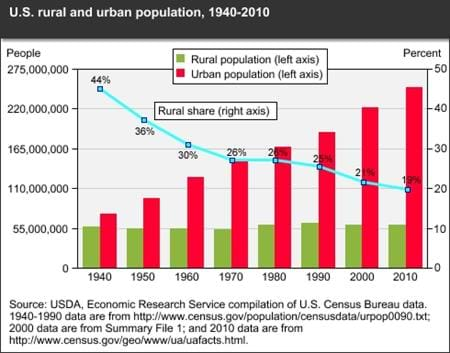
Urbanization remains a dominant trend in U.S. population change, but the rate of urbanization slowed during 2000-10. During the 1990s, the rural population declined from 61.7 million to 59.1 million and the share of the population living in rural areas dropped to 21 percent. In contrast, rural population grew by almost a half million people during 2000-10. Nonetheless, the rural population share continued to fall because urban areas continued to grow at a faster pace during the 2000s. During the 1950s and 1960s, migration from rural areas was a major contributor to urbanization, but today rural outmigration is less important than other demographic factors. Urban areas have a younger population and thus experience higher birth rates and lower death rates on average. Immigrants to the U.S. mostly choose urban destinations. In addition, suburbanization means that large portions of rural territory get reclassified as urban every decade. This chart is based on data available in the Rural Classifications topic on the ERS website, supplemented with historical U.S. Census Bureau data.

Wednesday, October 19, 2011
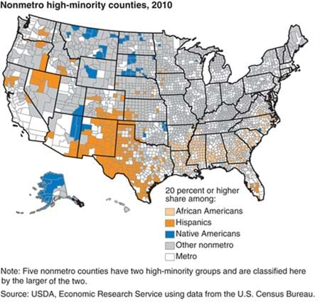
Despite relatively low population shares in nonmetro areas nationally (compared with metro areas), specific racial and ethnic groups are concentrated in some rural regions. In 2010, the African American share of population exceeded 20 percent in 290 nonmetro counties, almost all located in the Southeast. The Southwest and West contained the vast majority of the 211 nonmetro counties with 20 percent or more Hispanics, while the Northern Great Plains included most of the 57 counties with high shares of Native Americans. This map is from the 2011 edition of Rural America At A Glance, EIB-85, September 2011.


