

Mapping Frontier and Remote Areas in the U.S.
Researchers and policymakers focusing on rural development issues commonly use the term 'frontier' to denote relatively remote and sparsely settled territory, found largely but not exclusively in the Great Plains and Intermountain West. One need for delineating frontier areas comes from recent legislative mandates to improve access to public services in frontier areas. Health care access is the primary policy issue motivating this research, but remoteness also increases costs in accessing groceries (see the Food Desert Locator), household goods, child care, and publically provided social services, such as schools or fire protection. ERS's newly developed Frontier and Remote (FAR) area codes are both geographically detailed and adjustable within reasonable ranges to facilitate their use in diverse research and policy contexts. The initial set, based on urban-rural data from the 2000 decennial census, provides four separate FAR categories, ranging from one that is relatively inclusive (18 million FAR residents) to one that is more restrictive (4.8 million FAR residents).
Four FAR levels were developed because rural areas experience degrees of remoteness at higher or lower population levels depending on accessibility to different types of goods and services. A relatively large number of people live far from cities providing 'high-order' goods and services, such as advanced medical procedures, major household appliances, regional airport hubs, or professional sports franchises. Level One FAR codes are meant to approximate this degree of remoteness. A much smaller, but still significant, number of people find it hard to access 'low-order' goods and services, such as grocery stores, gas stations, and basic health care. Level Four FAR codes more closely coincide with this much higher degree of remoteness. Other types of goods and services--clothing stores, car dealerships, movie theaters--fall somewhere in between. Users of the ERS codes are able to choose the definition that bests suits their specific application.
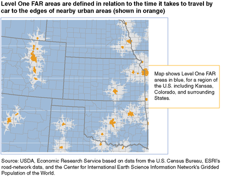
FAR areas are defined in relation to the time it takes to travel by car to nearby Urban Areas (UAs), defined by the Census Bureau to identify densely settled urban territory in a nationally consistent manner. Travel times to the edges of UAs are measured at the 1x1 kilometer grid level, using routing algorithms applied to a road network that includes all Federal, State, and county paved roads. Grid cells colored blue on the first map are Level One FAR areas, located 1 hour or more by car from UAs with populations of 50,000 or more people.
Using this travel time information linked to UA population size, it is possible to apply different sets of population and remoteness criteria, determine whether a grid cell qualifies as a frontier area at a given definitional level, and classify the grid cell population accordingly:
- Level One FAR areas consist of rural areas and urban areas up to 50,000 people that are 60 minutes or more by car from an urban area of 50,000 or more people (shown on first map).
- Level Two FAR areas consist of rural areas and urban areas up to 25,000 people that are 45 minutes or more by car from an urban area of 25,000-49,999 people and 60 minutes or more from an urban area of 50,000 or more people.
- Level Three FAR areas consist of rural areas and urban areas up to 10,000 people that are 30 minutes or more by car from an urban area of 10,000-24,999, 45 minutes or more from an urban area of 25,000-49,999 people, and 60 minutes or more from an urban area of 50,000 or more people.
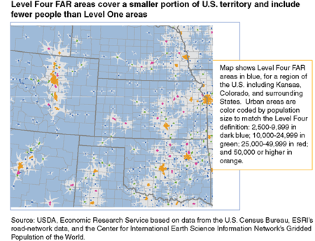
- Level Four FAR areas consist of rural areas that are 15 minutes or more by car from an urban area of 2,500-9,999 people, 30 minutes or more from an urban area of 10,000-24,999 people, 45 minutes or more from an urban area of 25,000-49,999 people, and 60 minutes or more from an urban area of 50,000 or more people (shown on second map).
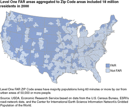
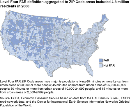
Once frontier categories are determined for each grid cell, frontier populations may be aggregated to larger, more useful geographic units, such as ZIP Code areas. For each ZIP Code area, the percent of the population defined as frontier was calculated. Most ZIP Code areas were either entirely frontier or entirely nonfrontier for a given level. For ZIP Code areas containing a mix of frontier and nonfrontier populations, classification was based on the status of the majority of the population.

U.S. population classified as FAR ranged from 6.5 percent (Level One) to 1.7 percent (Level Four) in 2000. Most of the population in both Wyoming and Montana resided in a Level One FAR area in 2000. The Dakotas showed the highest Level Four percentages by a significant margin. Only one Eastern State (Mississippi) had more than 25 percent of its population classified as FAR at Level One. Four States (Connecticut, Delaware, New Jersey, and Rhode Island) and the District of Columbia contained no FAR territory under any of the definitions applied here.
Frontier and Remote Area Codes, by John Cromartie, USDA, Economic Research Service, March 2024